| CPC H04N 7/183 (2013.01) [G01S 7/4812 (2013.01); G01S 7/4817 (2013.01); G01S 17/86 (2020.01); G01S 17/87 (2013.01); G01S 17/89 (2013.01); G01S 17/931 (2020.01); H04N 23/60 (2023.01); H04N 23/69 (2023.01); B60R 1/00 (2013.01); B60R 2300/101 (2013.01); B60R 2300/301 (2013.01)] | 21 Claims |
|
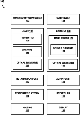
1. A method, comprising:
generating, using a light detection and ranging (lidar) sensor of a vehicle, a unit of sensing data comprising a direction and a distance to a reflective feature in an external scene;
capturing, using a camera sensor, a plurality of laterally offset images of the external scene, wherein a first image of the plurality of laterally offset images of the external scene is captured at a first time;
mapping, based at least on a scanning frequency associated with capturing the plurality of laterally offset images using the camera sensor, a first region of the first image to the unit of sensing data, wherein the first region depicts the reflective feature;
obtaining an augmented unit of sensing data, wherein obtaining the augmented unit of sensing data comprises:
fusing the unit of sensing data with the first region of the first image; and
delivering the augmented unit of sensing data to a navigation and pathing system of the vehicle.
|