| CPC G08G 1/0141 (2013.01) [G08G 1/0133 (2013.01); G08G 1/096725 (2013.01); G08G 1/096844 (2013.01); G08G 1/207 (2013.01)] | 11 Claims |
|
1. A mobility information provision system comprising:
a plurality of communication apparatuses provided in respective predetermined zones or respective predetermined sections on roads;
a server configured to:
collect, through one or more networks, field information or preliminary processed information using the plurality of communication apparatuses, the field information including information on movement of a plurality of mobile bodies, the preliminary processed information being obtained by processing the field information; and
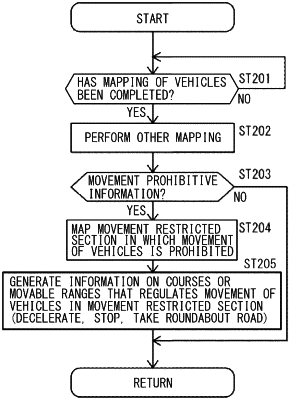
in a case where the field information or the preliminary processed information includes information that hinders the movement of the plurality of mobile bodies, the information that hinders the movement of the plurality of mobile bodies comprising road closure,
generate information of at least diagrams for each road and/or for each lane included in a lane road having lanes based on the field information, each of the diagrams including (1) a first axis representing a time, (2) a second axis being perpendicular to the first axis and representing positions along the each road or the each lane, and (3) a region defined by the first axis and the second axis,
map, when a mobile body included in the plurality of mobile bodies and traveling one of the each road or the each lane is detected based on the field information, at least a current position and a predicted position of the mobile body onto the region,
map, when a movement restricted section on the one of the each road or the each lane is detected based on the field information, a position of the movement restricted section onto the region, and
regulate the movement of the plurality of mobile bodies in the movement restricted section by generating the course-related information based on the diagrams, the course-related information including information of a course or a movable range for causing the mobile body to: (1) stop before the movement restricted section; and/or (2) take a roundabout road that includes a road or a lane excluding the one of the each road or the each lane; and
a controller provided for each of the plurality of mobile bodies and configured to control movement of corresponding one of the plurality of mobile bodies on a basis of the course-related information from the server to take the roundabout road, each of the plurality of mobile bodies comprising a vehicle.
|