| CPC G01V 99/005 (2013.01) [G01V 1/302 (2013.01); G06T 3/40 (2013.01); G06T 17/005 (2013.01); G06T 17/10 (2013.01); G06T 17/20 (2013.01); G06T 19/20 (2013.01); G01V 2210/64 (2013.01); G06T 2200/24 (2013.01); G06T 2210/36 (2013.01); G06T 2219/2021 (2013.01)] | 20 Claims |
|
1. A method comprising:
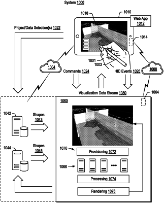
accessing volumetric data from a data store, wherein the volumetric data correspond to a region;
generating structured shape information for the region using at least a portion of the volumetric data, wherein the structured shape information is generated utilizing both a hierarchical structure of the volumetric data and a streamable shape specification comprising one or more types of shapes, wherein the one or more types of shapes are associated with a model of a portion of Earth; and
in response to a command from a client device, transmitting to the client device, via a network interface, a visualization data stream generated using at least a portion of the structured shape information for rendering of a visualization, wherein, during the transmitting, the visualization data stream progresses according to the hierarchical structure to increase a level of detail of the visualization with respect to time.
|