| CPC G01V 99/005 (2013.01) [E21B 44/00 (2013.01); E21B 47/022 (2013.01); G01V 1/50 (2013.01); G06F 17/18 (2013.01); G06T 17/00 (2013.01); G01V 2210/64 (2013.01)] | 20 Claims |
|
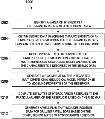
1. A computer-implemented method for optimizing and automating a well-planning process using an integrated multi-dimensional geological model, the method comprising:
identifying an area of interest in a subterranean region of a geological area;
obtaining seismic data describing characteristics of an underground formation in the subterranean region of the geological area;
modeling, by executing the integrated multi-dimensional geological model on the seismic data, properties of reservoirs in the underground formation, the modeling being based on the characteristics described in the seismic data, the integrated multi-dimensional geological model being trained with well log data that is correlated to formation data, the integrated multi-dimensional geological model configured to perform pattern matching based on one or more analytical rules generated based on the training data and the seismic data;
generating, by the integrated multi-dimensional geological model and based on the modeled properties of the reservoir, a risk map configured to estimate a probability of contacting a particular area of the reservoir that has properties corresponding to at least one of the modeled properties;
computing, by the integrated multi-dimensional geological model and based on the risk map, estimates of hydrocarbon reserves at the particular area of the reservoir;
based on the computed estimates of hydrocarbon reserves, generating, using the integrated multi-dimensional geological model, a well plan that includes position data for drilling a well bore to encounter the hydrocarbon reserves at the particular area of the reservoir, wherein the one or more analytical rules of the pattern matching are iteratively updating based on feedback data comprising seismic data generated at a location of the subsurface that is selected from the well plan; and
controlling, based on the well plan and the integrated multi-dimensional geological model, a drilling mechanism.
|