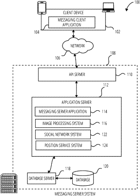
| CPC H04W 4/023 (2013.01) [G01C 21/005 (2013.01); G06F 16/909 (2019.01); G06F 17/18 (2013.01); H04W 4/021 (2013.01); H04W 4/029 (2018.02); H04L 67/01 (2022.05)] | 20 Claims |
|
1. A method comprising:
retrieving, using one or more processors, a current location of a client device;
generating an inaccuracy radius around the current location of the client device;
accessing geographic data based on the current location of the client device;
analyzing the geographic data to identify a plurality of geographic features;
prioritizing each geographic feature of the identified plurality of geographic features based on proximity to the current location of the client device, type of geographic feature and popularity of the geographic feature;
for each prioritized geographic feature of the plurality of geographic features, identifying a direction from the current location of the client device to the respective prioritized geographic feature, the direction comprising a distance and a bearing angle, and generating a confidence level indicating a probability that the current location of the client device is at the direction, the confidence level generated based on a geometry type of each prioritized geographic feature and a fraction of the inaccuracy radius that falls within the geometry type of each prioritized geographic feature;
returning the direction and the confidence level to the client device; and
based on the direction and confidence level, causing presentation of an avatar corresponding to a user of the client device on a user interface of the client device.
|