| CPC G06V 20/13 (2022.01) [G06V 10/22 (2022.01); G06V 10/25 (2022.01)] | 18 Claims |
|
1. A method comprising:
obtaining downward looking images of an area;
determining land types indicated in the images;
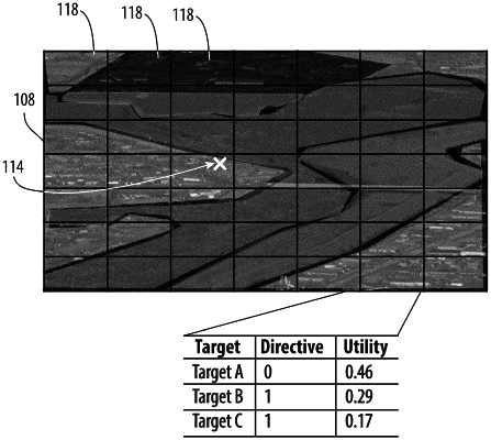
screening the images based on the land types wherein screened images pass screening based on land type more likely to include a target;
dividing each screened image into a grid of sub-images;
analyzing only the sub-images that include one or more land types likely to include the target, and foregoing analysis of other sub-images;
determining a weight for each sub-image based on a land-target score, a distance traveled, and a turn penalty; and
directing a physical resource to move toward one or more potential instances of the target if the weight of the one or more potential instances of the target is above a threshold;
obtaining one or more additional downward looking images; and
identifying the target in one of the one or more additional images.
|