| CPC G01V 8/10 (2013.01) [G01V 2210/62 (2013.01)] | 9 Claims |

|
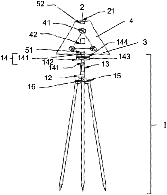
1. A method for transformation of point cloud coordinates of structure plane of deep-buried tunnel based on a target device, wherein the target device comprises a triangular target holder, a first plate surface, a second plate surface, and a third plate surface, wherein:
the first plate surface and the second plate surface are in the shape of an isosceles triangle, the third plate surface is in the form of an isosceles trapezoid; the triangular target holder is equipped, in ascending order, with a holder foot, a first circular level, a height adjuster, and a direction adjuster;
the triangular target holder is linked to the second plate surface using a direction adjuster, the bottom edge of the second plate surface is connected to the lower bottom of the third plate surface via a folding hinge, while the upper bottom of the third plate surface is connected to the bottom edge of the first plate surface via a folding hinge; the first plate surface and the second plate surface are fixedly connected via a post holder, and the central position of the first plate surface houses the second circular level; the third plate surface features three cross targets, and a three-dimensional electronic compass with a digital display is situated at the center of the third plate surface;
prior to conducting laser scanning on a surface being measured, the target device is adjusted to bring the third plate surface close to the measured surface, ensuring that bubbles in the first circular level and the second circular level are centered;
acquiring point cloud data of both the measured surface and the target device is achieved through the utilization of a three-dimensional laser scanner;
individually retrieving the point cloud coordinates of the three cross targets from the point cloud data, and obtaining the initial orientation of the third plate surface from the digital display of the three-dimensional electronic compass;
determining the second tendency of the third plate surface based on the point cloud coordinates;
converting the coordinates in the point cloud data to geodetic coordinates according to the first tendency and the second tendency.
|