| US 11,808,856 B1 | ||
| Robust laser scanning for generating a 3D model | ||
| Nathan L. Tofte, Downs, IL (US); Patrick H. Boyer, Bloomington, IL (US); and James M. Freeman, Normal, IL (US) | ||
| Assigned to STATE FARM MUTUAL AUTOMOBILE INSURANCE COMPANY, Bloomington, IL (US) | ||
| Filed by STATE FARM MUTUAL AUTOMOBILE INSURANCE COMPANY, Bloomington, IL (US) | ||
| Filed on Apr. 20, 2020, as Appl. No. 16/852,731. | ||
| Application 16/852,731 is a continuation of application No. 15/598,071, filed on May 17, 2017, granted, now 10,663,591, issued on May 26, 2020. | ||
| Int. Cl. G01S 17/89 (2020.01); G01S 7/481 (2006.01); G01S 7/48 (2006.01); G01S 7/497 (2006.01); G01S 17/88 (2006.01); G01S 17/66 (2006.01); G01S 7/00 (2006.01); G01S 17/42 (2006.01); G01S 17/10 (2020.01); B64U 101/00 (2023.01); B64U 101/30 (2023.01) | ||
| CPC G01S 17/89 (2013.01) [G01S 7/003 (2013.01); G01S 7/4808 (2013.01); G01S 7/4817 (2013.01); G01S 7/4972 (2013.01); G01S 17/10 (2013.01); G01S 17/42 (2013.01); G01S 17/66 (2013.01); G01S 17/88 (2013.01); B64U 2101/00 (2023.01); B64U 2101/30 (2023.01)] | 16 Claims |

|
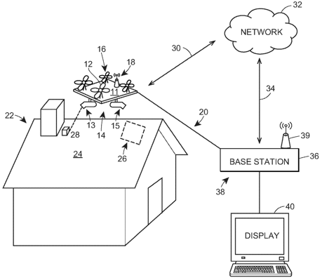
1. A property inspection system for scanning a structure with one or more structure scanners, the property inspection system comprising:
a three-dimensional fiducial marker with a known size and shape having unique 3D surface features at a known location on the surface of the structure; and a structure scanner mounted to a flying device, the structure scanner comprising:
(i) a laser tracking device configured to obtain a scan of the unique 3D surface features of the three-dimensional fiducial marker;
(ii) a laser scanning device configured to scan a portion of the surface of the structure to obtain a 3D representation of the portion of the surface; and
(iii) one or more processors configured to:
(a) analyze the scan of the three-dimensional fiducial marker to generate an estimate of an orientation and position of the structure scanner based on the scan of the unique 3D surface features of the three-dimensional fiducial marker;
(b) use the estimated orientation and position of the structure scanner to estimate a real-world position of the portion of the surface represented by the 3D representation; and
(c) map the 3D representation of the portion of the surface of the structure to a 3D model of the structure based, at least in part, on the estimated real-world position of the portion of the surface; and
(d) generate an estimate of a condition of the structure based on the 3D model of the structure.
|