| CPC G06T 7/162 (2017.01) [G06T 7/136 (2017.01); G06T 7/246 (2017.01); G06T 7/73 (2017.01); G06T 2207/20072 (2013.01); G06T 2207/20076 (2013.01); G06T 2207/30244 (2013.01)] | 11 Claims |
|
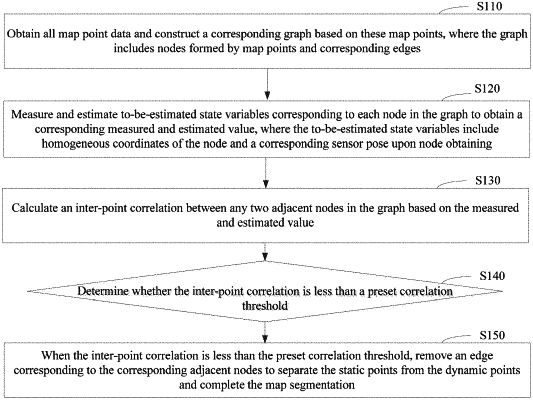
1. A map segmentation method executed by one or more computer devices to segment a map, wherein the map comprises static points and dynamic points, and the map segmentation method comprises:
obtaining map point data and constructing a corresponding graph based on the map point data, wherein the corresponding graph comprises nodes formed by map points and corresponding edges;
measuring and estimating to-be-estimated state variables, each to-be-estimated state variable respectively corresponding to each node in the corresponding graph, and each to-be-estimated state variable measured and estimated to obtain a corresponding measured and estimated value, wherein each to-be-estimated state variable comprises homogeneous coordinates of the node and a corresponding sensor pose at a time of obtaining the node;
calculating an inter-point correlation between any two adjacent nodes of the nodes in the corresponding graph based on the measured and estimated values associated with the two adjacent nodes;
determining whether the inter-point correlation is less than a preset correlation threshold; and
removing, in a state in which the inter-point correlation is less than the preset correlation threshold, an edge corresponding to the two adjacent nodes to separate the static points from the dynamic points and complete the map segmentation,
wherein the inter-point correlation is calculated according to the following formula:
 wherein Zijk represents the inter-point correlation between the i-th map point and a i-th map point in the corresponding graph at time k; yik represents the corresponding measured and estimated value corresponding to an i-th map point in the corresponding graph at time k; yjk represents the measured and estimated value corresponding to the i-th map point in the corresponding graph at time k; lijk represents an edge connecting the i-th map point and the i-th map point at time k; h(lijk) represents a model observation value corresponding to the inter-point correlation between the i-th map point and the i-th map point at time k; Pj represents homogeneous coordinates corresponding to the i-th map point; nijk represents noise; s(.) represents a sensor model; Tk represents a motion of a sensor at time k; and Pi represents homogeneous coordinates corresponding to the i-th map point.
|