| CPC H04L 41/0677 (2013.01) [H04L 45/22 (2013.01); H04L 45/28 (2013.01)] | 13 Claims |
|
1. A system comprising:
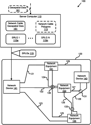
a server computer, configured to:
receive geospatial data for a plurality of network cables in a computer network,
identify network cables, of the plurality of network cables, that are located within a specified distance from one another based on the geospatial data for the plurality of network cables,
create shared risk link groups (SRLGs) associated with the identified network cables, of the plurality of network cables, and
transmit the SRLGs to a network device in the computer network; and
the network device, wherein the network device is configured to:
receive the SRLGs from the server computer, and
determine a backup network path for a network path in the computer network comprising one or more network cables, of the plurality of network cables, using the SRLGs;
wherein the server computer identifies the network cables by being configured to:
define a plurality of polygons for the plurality of network cables based on the geospatial data for the plurality of network cables;
group two polygons of the polygons that intersect one another into a first polygon group;
determine that a second polygon group contains a polygon associated with a same network cable as the first polygon group; and
combine the first polygon group and the second polygon group into a single polygon group as a result of both the first polygon group and second polygon group having the same network cable.
|