| CPC G05D 1/0094 (2013.01) [B64C 39/024 (2013.01); B64D 47/08 (2013.01); G01C 11/02 (2013.01); G06Q 40/08 (2013.01); G06V 10/225 (2022.01); G06V 10/235 (2022.01); G06V 20/176 (2022.01); G06V 20/58 (2022.01); G06V 20/64 (2022.01); G08G 5/0069 (2013.01); G08G 5/045 (2013.01); H04N 7/183 (2013.01); H04N 7/185 (2013.01); H04N 23/66 (2023.01); B64U 2101/30 (2023.01); B64U 2201/10 (2023.01)] | 12 Claims |
|
1. An unmanned aerial vehicle (UAV) assessment and reporting system for analyzing a structure, comprising:
(a) a site selection interface to receive an electronic input identifying a location of a structure;
(b) a boundary identification interface to receive electronic input identifying geographic boundaries of an area that includes the structure; and
(c) a UAV to receive the geographic boundaries and the location of the structure from the site selection interface, the UAV comprising:
a camera to capture images of the structure;
a camera adjustment component to adjust an angle of the camera relative to the UAV;
a processor in communication with the camera; and
a non-transitory computer-readable medium for receiving and storing instructions that, when executed by the processor, cause the UAV to conduct a structural assessment, the operations comprising a plurality of assessments including:
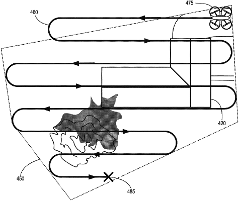
a boustrophedonic scan of the area in a first boustrophedonic flight pattern defined by the identified geographic boundaries that include the structure, the boustrophedonic scan including:
image capture during the first boustrophedonic flight pattern within a first altitude range, and
a determination of distances to a surface for each of a plurality of potential vertical approaches within the area defined by the identified geographic boundaries that include the structure;
identifying a structure on the site based on at least one of the identified geographic boundaries and the boustrophedonic scan of the area;
a loop scan of the structure, the loop scan including a second flight pattern for the UAV to travel around a perimeter of the structure at a second altitude range lower than the first altitude range, and
a micro scan of the structure in a third flight pattern that includes vertical approaches proximate the structure to capture detailed images of the structure.
|