| CPC G08G 5/0069 (2013.01) [B64C 39/024 (2013.01); G06V 20/39 (2022.01); G08G 5/003 (2013.01); G08G 5/006 (2013.01); G08G 5/0013 (2013.01); G08G 5/0026 (2013.01); G08G 5/0034 (2013.01); G08G 5/0086 (2013.01); B64U 2101/30 (2023.01); B64U 2201/104 (2023.01)] | 30 Claims |
|
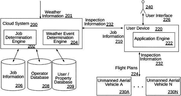
1. A method comprising:
determining an upcoming weather event and one or more areas expected to be affected by the upcoming weather event based on outputs from a plurality of sensors monitoring features of weather events;
determining that a likelihood of damage associated with the upcoming weather event in the one or more areas is greater than a first threshold using machine learning models trained on historical weather event information;
based on the likelihood of damage being greater than the first threshold, determining that severity information associated with the upcoming weather event within the one or more areas is greater than a second threshold;
determining, prior to the upcoming weather event, properties to be inspected within the one or more areas by one or more unmanned aerial vehicles (UAVs) based on the severity information being greater than the second threshold;
automatically initiating, subsequent to the upcoming weather event, an initial UAV inspection of the properties determined based on the severity information being greater than the second threshold to identify a subset of the properties for which to perform detailed UAV inspections, wherein the initial UAV inspection is performed using a first UAV to navigate about the one or more areas according to a first flight pattern to obtain initial sensor information;
analyzing the initial sensor information from the initial UAV inspection performed using the first UAV to identify the subset of the properties by identifying damage to particular properties indicated by the initial sensor information; and
automatically initiating, subsequent to the initial UAV inspection, based on the initial sensor information obtained by the first UAV, the detailed UAV inspections of the subset of the properties, wherein the detailed UAV inspections are performed using a second UAV to navigate the subset of the properties according to a second flight pattern to obtain detailed sensor information of the particular properties.
|