| CPC G05D 1/0038 (2013.01) [G06F 16/29 (2019.01); G06F 18/2178 (2023.01); G06V 10/22 (2022.01); G06V 10/763 (2022.01); G06V 10/7784 (2022.01); G06V 20/17 (2022.01); G06V 20/188 (2022.01); G08G 5/0039 (2013.01); B64C 39/024 (2013.01); G06V 20/194 (2022.01)] | 20 Claims |
|
1. A system for monitoring environments, the system comprising:
a base station comprising a first processing system including at least one first processor; and
an unmanned aerial vehicle (UAV) comprising a second processing system including at least one second processor, wherein the UAV is in communication with the base station,
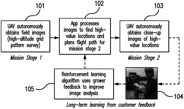
wherein the second processing system of the UAV is configured to capture a plurality of initial images of a predetermined area to obtain coverage of the predetermined area at a lower spatial resolution as the UAV flies along a flight path, wherein the flight path for the UAV is above the predetermined area, and wherein the second processing system of the UAV is configured to transmit the plurality of initial images to the first processing system of the base station,
wherein the first processing system of the base station is configured to analyze the at least one of the plurality of initial images to automatically identify areas within the at least one of the plurality of initial images that deviate from a determination of an average of the plurality of initial images and that represent anomalous places within the predetermined area to identify a plurality of agronomically anomalous target areas, and wherein the plurality of agronomically anomalous target areas together comprise a set of agronomically anomalous target areas,
wherein the first processing system of the base station is configured to assign geolocations to each of the agronomically anomalous target areas of the set, wherein the first processing system of the base station is configured to select one or more of the agronomically anomalous target areas of the set to form a subset of one or more agronomically anomalous target areas, wherein a number of agronomically anomalous target areas in the set is larger than is in the subset, wherein each agronomically anomalous target area in the subset is selected by the first processing system of the base station as a result of that agronomically anomalous target area being larger than at least one agronomically anomalous target area of the set that is excluded from the subset, and wherein the first processing system of the base station is configured to transmit an updated flight path to the second processing system of the UAV directing the UAV to the one or more agronomically anomalous target areas of the subset,
wherein the second processing system of the UAV is configured to, in response to receiving identification of the one or more agronomically anomalous target areas of the subset, automatically cause the UAV to capture one or more additional high resolution images of the one or more agronomically anomalous target areas of the subset, and
wherein the second processing system of the UAV is configured to transmit the one or more additional high resolution images to the first processing system of the base station.
|