| CPC G01S 3/801 (2013.01) [G01S 3/802 (2013.01); G06F 3/0412 (2013.01); G06F 3/0488 (2013.01); G06F 3/04845 (2013.01); G09B 29/003 (2013.01); H04N 1/00411 (2013.01)] | 20 Claims |
|
1. A system for presenting marine information, wherein the system comprises:
at least one array of a plurality of sonar transducer elements associated with a watercraft on a body of water and oriented with an emitting face in a facing direction, wherein the plurality of sonar transducer elements are configured to operate at a fixed phase shift and vary in frequency so as to beamform multiple sonar return beams based on one or more sonar beams transmitted into the underwater environment;
a display;
one or more processors; and
a memory including computer program code configured to, when executed, cause the one or more processors to:
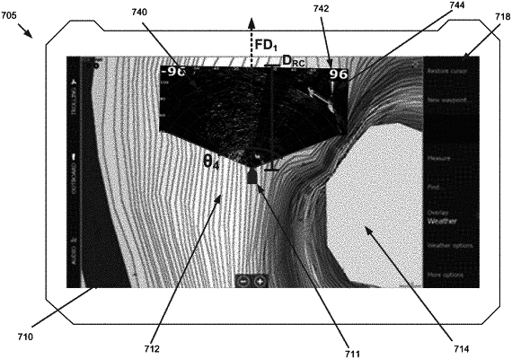
cause, on the display, presentation of a chart including at least a portion of the body of water;
cause, on the display, presentation of a representation of the watercraft at a position on the chart corresponding to a current location of the watercraft;
receive sonar return data from the plurality of sonar transducer elements of the at least one array;
filter the sonar return data based on frequency to form the multiple sonar return beams that together form a coverage area in a horizontal plane extending outwardly from the watercraft, wherein the coverage area extends a radial distance outwardly from the emitting face;
generate a sonar image of the underwater environment outward from the watercraft, wherein the sonar image is a two-dimensional live sonar image that is formed of the sonar return data from each of the multiple sonar return beams, and wherein the sonar return data used to form the two-dimensional live sonar image was received at substantially a same time by the plurality of sonar transducer elements, wherein the sonar return data used to form the two-dimensional live sonar image is updated in real-time;
determine the facing direction; and
cause, on the display, presentation of the sonar image in the facing direction on the chart and relative to the representation of the watercraft, wherein the sonar image extends outwardly from the representation of the watercraft on the chart a distance dimensionally corresponding to the radial distance of the coverage area to thereby visually indicate a real world coverage area of the two-dimensional live sonar image, wherein the sonar image is presented in the facing direction on the chart so as to visually provide a relationship between objects within the live sonar imagery and a real-world position of the objects.
|